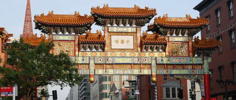
Where is the center of D.C.’s Chinatown? The easy answer would be Friendship Archway, the dazzlingly colorful landmark adjacent to the Gallery Place metro stop, which was gifted to Washington by the Municipality of Beijing.
While that might be the symbolic center, the functional center of the rapidly growing residential community is two blocks away, centered on a small triangular parcel called Chinatown Park. Elderly residents from nearby Wah Luck House remember when the park buzzed with activity; now, it is a location where long-time residents meet their new neighbors living across Massachusetts Avenue.
“Elderly residents living in Wah Luck House really miss hanging out at the park in a quiet atmosphere,” said Sara Harvey, a graduate student in Georgetown University’s Master's in Urban & Regional Planning program. “Now, the park is at the center of a completely new and growing demographic.” Harvey interviewed the residents for a class last semester called Shaping the Urban Corridor: Leveraging Convention; Embracing Innovation Along Massachusetts Avenue.
“The purpose of this planning studio was to position students to marry new means of collecting digital geo-scraped data with on-the-ground observations of the same place,” commented Jess Zimbabwe, instructor in the Urban & Regional Planning program. “By doing so, the students are able to explore how each of those sources of data feed into a contemporary urban design process.”
Honoring the Past, Embracing the Present
Over the course of the semester, students analyzed a 2.1-mile stretch of Massachusetts Avenue, from Dupont Circle to Union Station, and made proposals for making it more vibrant, inclusive, and cohesive. Unlike other major corridors in the city, like Pennsylvania Avenue or New York Avenue, Massachusetts Avenue has not been re-conceptualized over the last 20 years of rapid growth in the city.
The students divided the urban corridor into five segments, with Harvey focusing on the area around Chinatown. Her proposal envisions the park, now little more than a grassy patch with a few trees and paths, as the kind of meeting place it was before, a place where all residents and visitors can congregate and learn about Chinatown’s rich history and culture through interpretive exhibits and neighborhood festivals.
This unassuming park “is right down the road from the row of embassies,” Harvey said, “so it creates a local to global connection for all who walk through the park.”
Massachusetts Avenue was an integral urban element of the master plan laid out by Pierre L’Enfant in 1791, but episodic development over the past half century has made the historic thoroughfare functionally and aesthetically disjointed. And yet, the avenue establishes the urban address for a remarkable number of globally significant institutions, including international embassies, blue-chip think tanks, the Walter E. Washington Convention Center, and unique historic buildings like the Carnegie Library Apple Store and prominent churches.
“It’s an avenue that can and should have a more prominent role to play in the city,” said Teaching Assistant Femi Adelakun, an urban planner and co-founder of the consulting firm City 78. “But it’s just been looked over in terms of it serving as an iconic civic place.”
Identifying ‘Assets’ and ‘Risks’
The class turned to new data tools developed by the geo-spatial software firm ESRI and Adelakun’s firm. Using a tool called the Neighborhood Performance Indicator, the students were able to use artificial intelligence to analyze the many thousands of comments people have posted on sites such as Google and Yelp. Students analyzed more than 24,000 comments made at 286 points along the 2.1-mile study area. This crowdsourced input was then sorted to identify urban “assets,” “risks,” and other assessments of the corridor.
“You get a more vivid real-time picture of how people use and experience urban spaces,” Adelakun said.
This technology came in handy for Nick Peavy, a student whose project repositions Scott Circle to be safer and more visually appealing for pedestrians. “Do we need a circle that has 24 stoplights to manage vehicle flows?” Peavy asked when he and the other students presented their proposals to a group of experts. “That might be a little over-engineered.”
Making Scott Circle a Livable Place
Peavy’s plan for the traffic might seem counterintuitive, but it has worked in other places: Remove the stoplights and let motorists merge on their own, something he said leads to slower, more careful driving—and safer crossings for pedestrians.
Peavy also proposed connecting the pedestrian space of the circle to the adjacent triangular “bow-tie” mini-parks (ubiquitous across L’Enfant’s Washington) by adding green space and color-coded crosswalks. This would prioritize pedestrian movements over those of cars, similarly implemented at the Wharf or in the superblocks initiative in Barcelona, Spain.
“We should think of the Massachusetts Avenue corridor as a naturally occurring urban innovation district of global significance,” commented Uwe Brandes, Faculty Director of the Urban & Regional Planning program. “These students are sending our studio collaborators a clear message: Put people first when allocating the use of the public realm.”Learn more